Wolfsburg is constantly developing! To ensure competitiveness and quality of life in Wolfsburg for the future, there needs to be room for change and expansion.
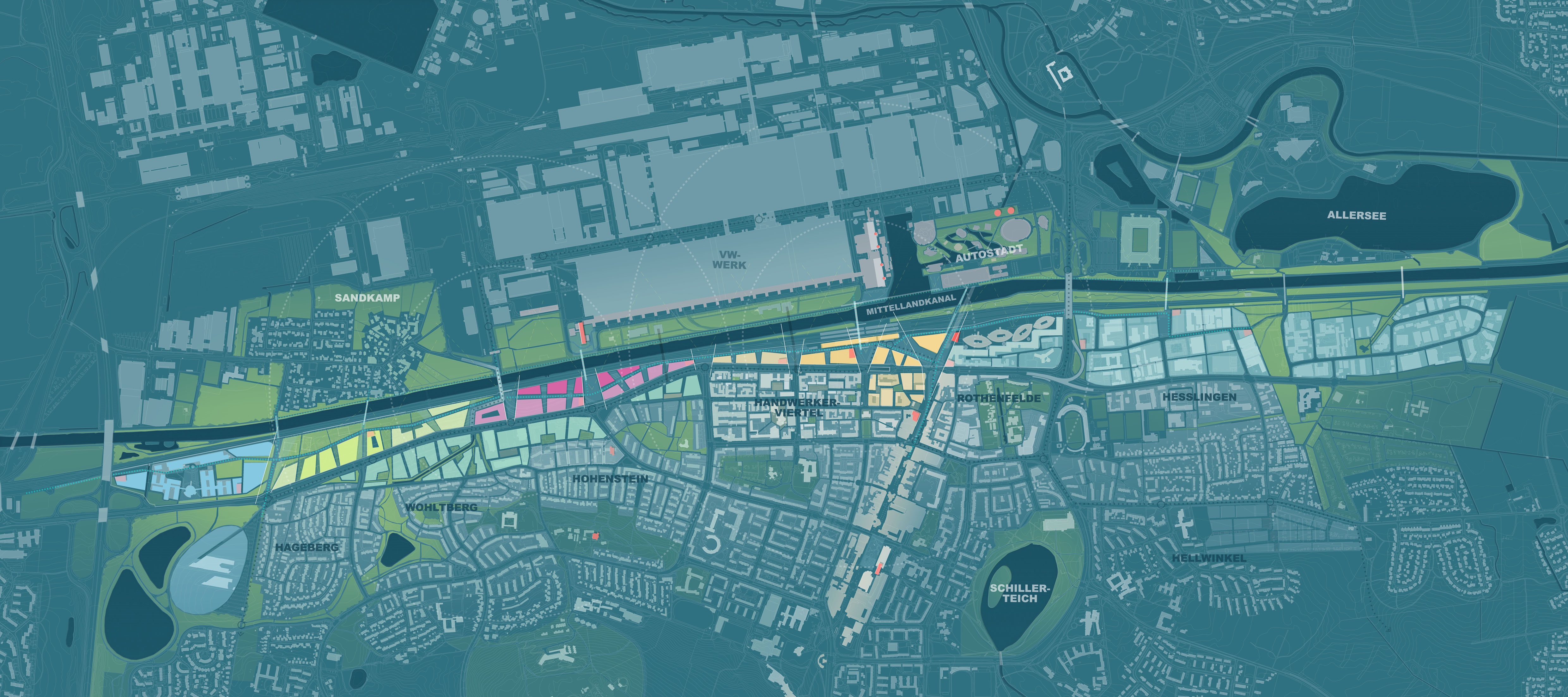
The most sustainable - and at the same time associated with major challenges - is the redevelopment of previously underused, centrally located areas in the city. The Nordhoffachse master plan shows how and where development is possible and what needs to be considered in the process. Along the Mittelland Canal and the rail line between the city center and the Volkswagen plant, about 13,000 people could work and 7,000 people could live in the next 20 to 30 years. Starting from the main train station with a new central ZOB, three mixed-use neighborhoods can gradually emerge along an innovation route: The Quartier am Nordkopf (yellow), the VW Campus (pink, focus on working) with a new regional train stop, and the Quartier am Mittellandpark (light green, focus on living). The "windows to the factory" provide a view across the canal to the industrial monument that characterizes the cityscape. The existing neighborhoods of Hageberg, Wohltberg and Hohenstein move closer to the south side of Heinrich-Nordhoff-Strasse (green). A quality bus runs in a dedicated lane, connecting the P R services in the southeast and southwest of the city with the plant and the main train station. The innovation route located inside the new quarters provides space for pedestrians, cyclists and new micromobility services.
Crossing, networking, moving on
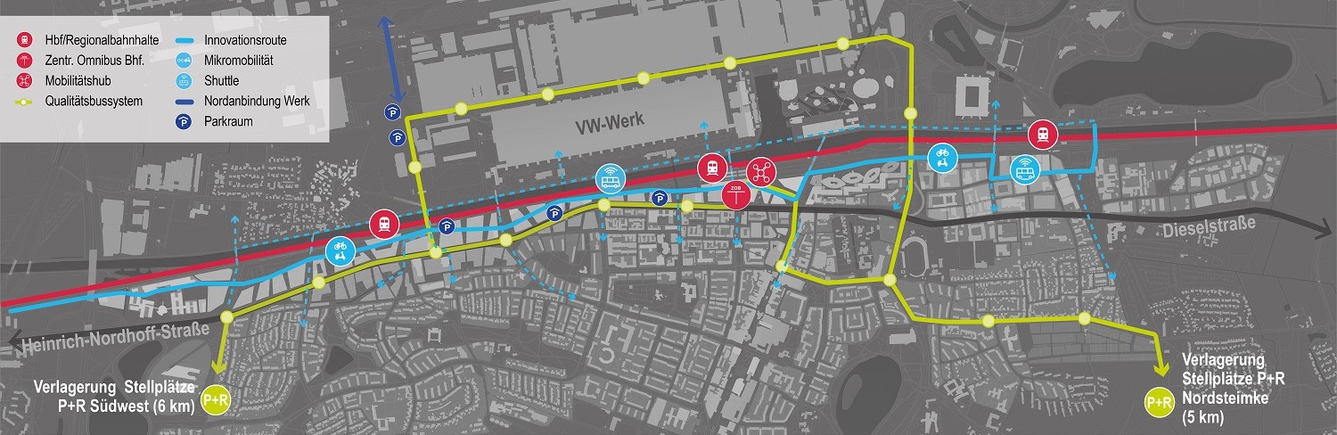
The basic framework of the traffic development is based on various mobility offers. By rail, the current main station will be supplemented by a new regional train stop at the Oststrasse bridge. On the road, a quality bus system on dedicated lanes in conjunction with P R facilities in the southeast and southwest will ensure fast, convenient and direct connections to the plant and the Nordhoff axis. The hub is a new, centrally located ZOB at the main train station. The all-connecting innovation route is reserved for pedestrians, cyclists and new mobility solutions. Future relief from motor vehicle traffic is to be achieved by a northern connection to the VW plant with new parking facilities.
The green ribbon on the water
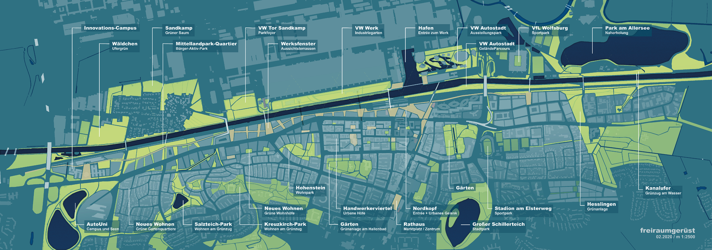
The master plan features existing and new open spaces that are interconnected. The Mittellandkanal with its north and south banks becomes a meeting and transit space for leisure and recreation. It connects open space structures in the east and west and thus simultaneously closes the green ring around the city center. As a counterpart, the innovation route opens up smaller-scale open spaces such as plazas, windows and neighborhood joints within the construction areas. In addition to the bridges, the exciting and varied green basic framework enables diverse access from the southern urban space to the new quarters along the Nordhoff axis and to the canal. This makes the city much more attractive for new and old residents of Wolfsburg.
In a four-episode video podcast, Michael Heller, architect of the planning office Albert Speer und Partner (AS P) from Frankfurt/Main, explains,
- what had to be considered in the master plan Nordhoffachse (part 1 - exploration phase)
- what the design looks like (part 2 - design phase),
- what the result of the strategic planning is (part 3 - result phase) and
- what summarizes the master plan (Part 4 - Summary).
Before a new district can be developed, the basic structures must first be determined: Where could there be development? Where should there be green spaces? How will the planned area be developed? A master plan is being drawn up for this purpose. It is more or less a director's book and describes the development of the neighborhood from an urban planning, open space and traffic planning perspective. A master plan represents a declaration of intent formulated well in advance and makes initial statements on functions and quality targets. The concept must be flexible and capable of being updated. This means that adjustments to changing framework conditions and development needs are possible at any time during the further planning process.
Details, such as exactly where a path runs in a parking area or the design of a building, are not yet specified in a master plan. Furthermore, a master plan does not yet create building rights. Rather, this requires individual development plans to be drawn up in each case, for which the public must be involved and whose preparation and statutes must be approved by the Wolfsburg City Council.
Sustainable urban quarters are to be created along the Mittellandkanal and Heinrich-Nordhoff-Strasse, further overcoming the historical separation between the factory site and the city center. The key objective is the visionary further development and strengthening of Wolfsburg as a residential and business location and the realization of sustainable mobility concepts. In an unrivaled location with an ICE stop and future regional stop, supplemented by a quality bus system and connected by an innovation route, a place to live and work could emerge in the future.
In December 2017, the Wolfsburg City Council decided to develop a master plan for the area of Heinrich-Nordhoff-Strasse from the St.-Annen junction to highway 39. After a multi-stage negotiation process, a committee recommended that the AS P office from Frankfurt be commissioned with the master planning. The planning office began work in the fall of 2018. At the beginning of 2019, a mentoring circle was introduced, which meets twice a year, consists of representatives from politics, Volkswagen AG, external consultants and the city of Wolfsburg, and actively accompanies the master planning process. In the reconnaissance phase, the AS P planning team collected basic data and information in fact sheets. In the subsequent design phase, ideas were tested and coordinated with the mentoring group. The basic structures were defined in the final results phase.
The Wolfsburg City Council adopted the master plan in principle on February 10, 2021. The development horizon for the entire axis is designed for a long period, probably several decades. Short-term changes are to be expected first and foremost in the area of the Nordkopf. With the contents of the master plan as a basis, the investor SIGNA is currently preparing an urban design for the area between Lessingstraße and the main train station and will carry out public participation.
Here you can download the detailed technical reports on the exploration, design and results phase from the AS P planning office, as well as draft resolutions and information.
- Part 1 - Report of the exploration phase
- Part 2 - Report of the design phase
- Part 3 - Report of the results phase
- Draft resolution on the implementation of master planning (V 2017/0543)
- Information on the commissioning and status of master planning (K 2018/0369)
- Information on the processing strategy of the master planning (K 2019/0458)
- Draft resolution on the continuation of master planning (V 2019/1200)
- Basic decision on master planning for the Nordhoff axis (V 2020/1549-4)
- Flyer
Contact
City of Wolfsburg
Citizen's office with an impact
City of Wolfsburg
City Hall A, Room A 101
Porschestrasse 49
38440 Wolfsburg
Phone: 05361 28-2000
E-mail to Bürgerbüro mitWirkung