-
Initial situation
Against the background of the very dynamic development of the city in recent years (high increase in inhabitants and jobs), public transport should in future represent an attractive alternative to the use of one's own motor vehicle for various user groups in everyday mobility. To achieve this, it is essential to push ahead with the further development of the bus route network and to tackle the development of routes for a high-quality public transport system.
The initial idea for the AGR was to guide bicycles and buses along a common route as quickly as possible and independently of motor vehicle traffic. However, in further work it became clear that the requirements for public transport and bicycle traffic are very different. The goal for public transport is to have it run on a congestion-free connection with few stops, with central transfer possibilities, with short distances to the stops and bus priority between Nordsteimke/Hehlingen and the city center. For bicycle traffic, on the other hand, routes with few inclines, the shortest possible distances, traffic-safe routes, and social safety are important. This results in different routes for the public transport connection and the bicycle routes.
-
Variant identification and evaluation
fast bus system
For the realization of the AGR, different variants of the route for the city center were examined in the course of a feasibility study. In the study, four possible routes with various sub-variants were considered step by step. In each case, the most suitable sub-variant was included in the further evaluation stage. The comparison of variants was carried out both for a light rail system and for a tram system. With the help of an objective evaluation procedure, the optimal variant could be determined. In the process, care was taken to ensure that the evaluation met the requirements of all stakeholders involved, such as customers, transport companies, the municipality and the general public, in equal measure.
The evaluation criteria included:
- Travel time
- Number of transfers
- Possibilities for separate lane guidance and public transport priority at the traffic lights
- Construction costs and economic efficiency
- Impact on the cityscape and landscape and encroachment of land
- Connection of the new and old residential areas in the southeast of Wolfsburg
- high attractiveness to create an incentive for commuters to switch to public transport
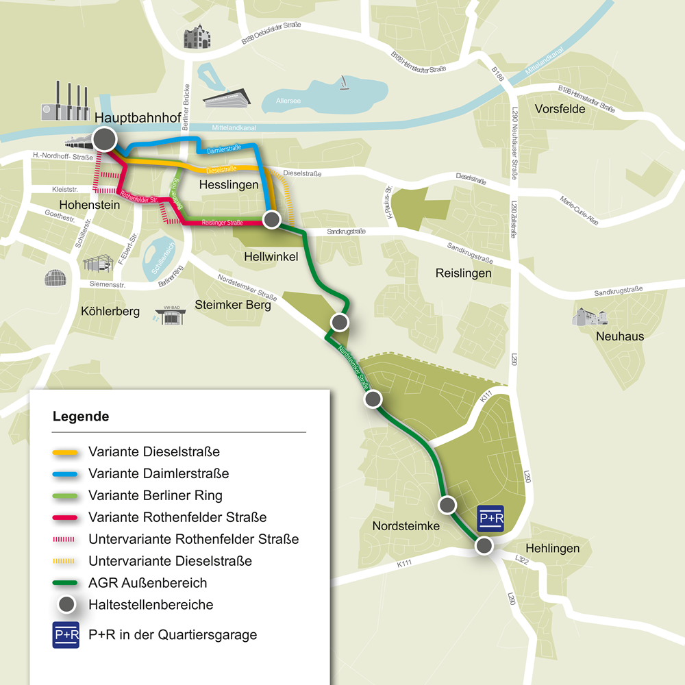
The following variants have been studied for the AGR inner city route.
Variant Daimlerstrasse
Variant Daimlerstrasse
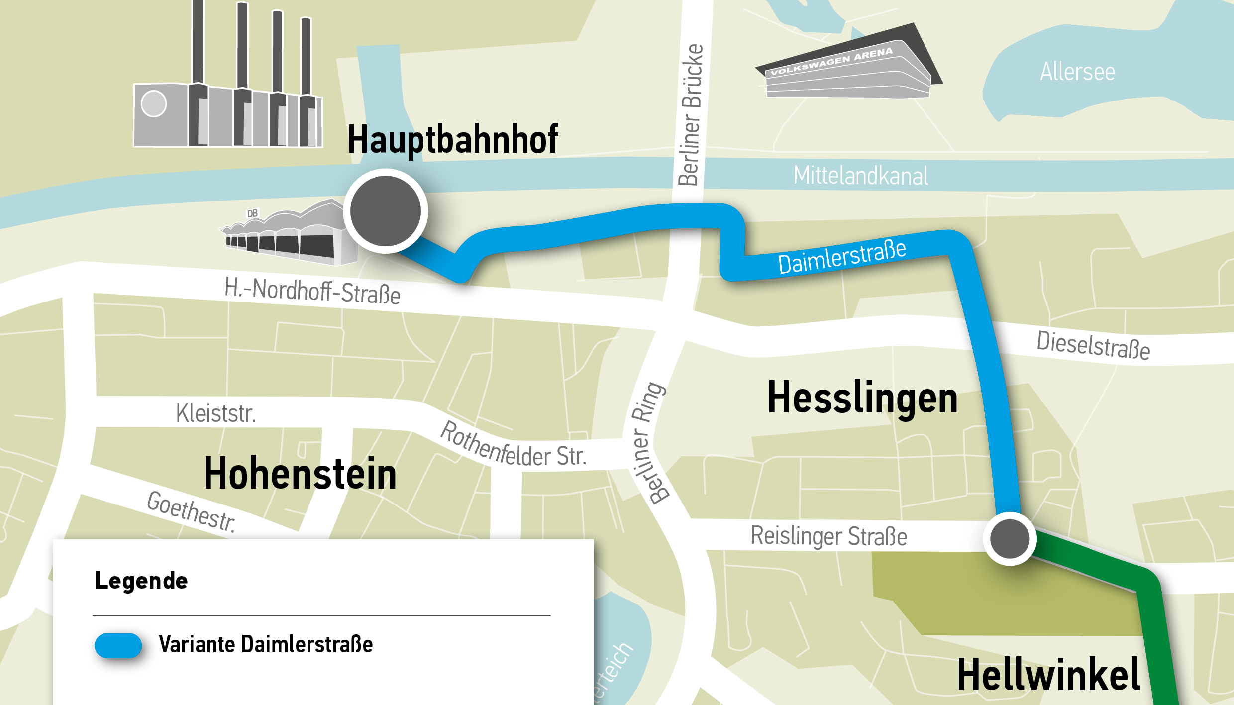
- Variant runs via Lerchenweg and Daimlerstraße
- no separate lane guidance for public transport would be possible on this route in its entire course
--> therefore no time advantage compared to the motor vehicle traffic
Variant diesel road
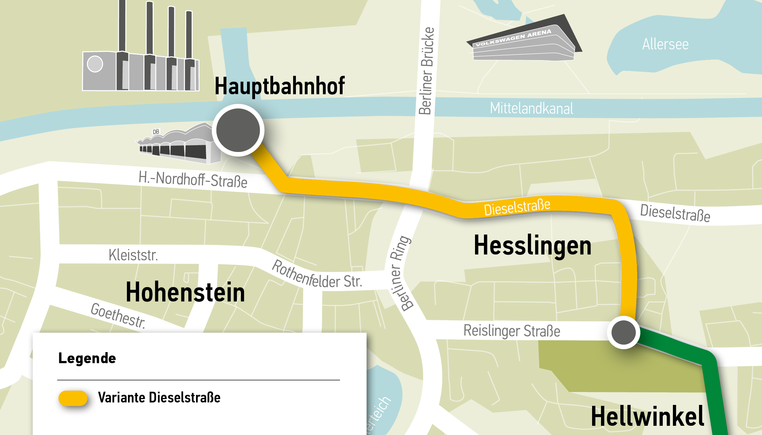
- Variant runs via Lerchenweg and Dieselstraße to the main station
- in the area of Lerchenweg no separate lane guidance is possible
- in the area of Dieselstraße, the route contradicts the traffic concept for motor vehicle traffic (strengthening the Dieselstraße - L 290 axis)
- Due to regular interventions by the professional fire department, mutual obstructions are to be expected at the height of the fire station.
Variant Berliner Ring
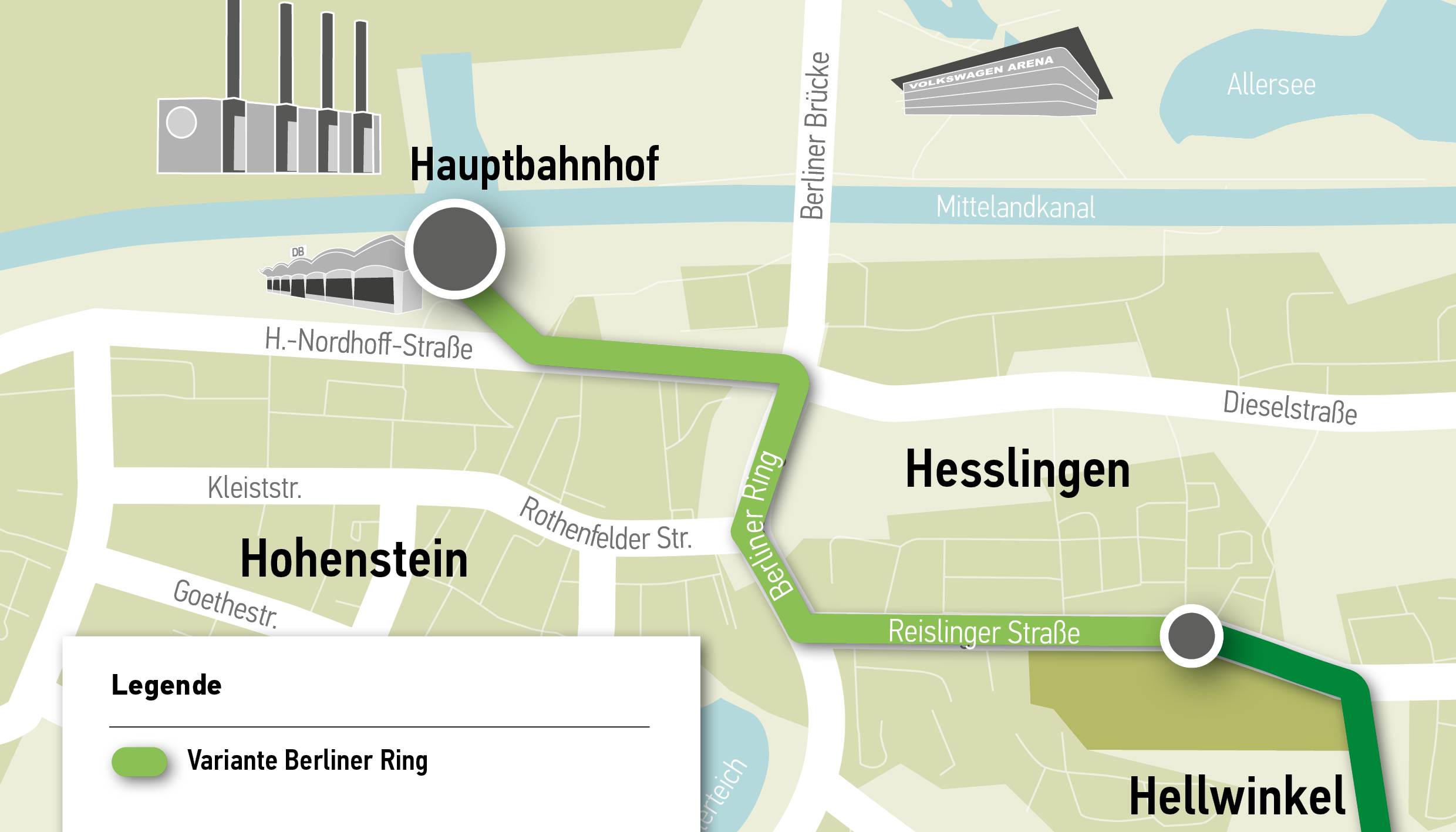
- Variant runs along Reislinger Straße, Berliner Ring and Heßlinger Straße to the main train station
- possible conflicts with urban development along the Berliner Ring
- at the St.-Annen junction, the route conflicts with the Wolfsburg Southeast traffic concept for motor vehicle traffic
- no separate lane is possible in Heßlinger Straße at the access to the tunnel
Rothenfelder Street variant
Rothenfelder Street variant
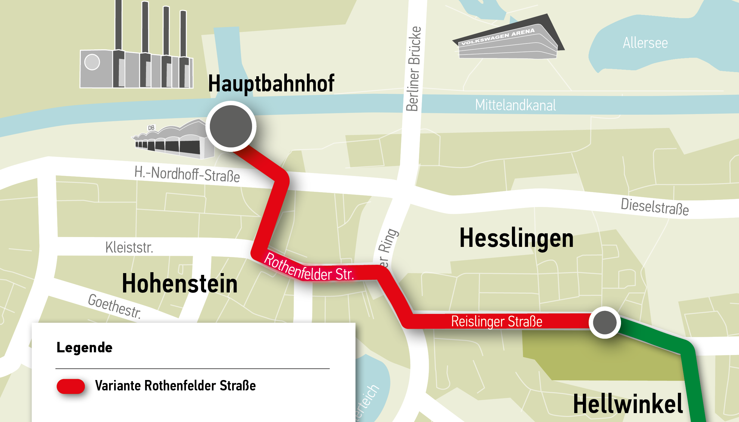
- Variant runs via Reislinger Straße, Berliner Ring, Rothenfelder Straße and Porschestraße to the main station
- a connection to the city center is possible by additional stops in the central city area
- A separate lane for the AGR in the Rothenfelder Straße/Dieselstraße area is accompanied by a reduction in parking spaces and a restriction on the passage of motor vehicle traffic.
--> variant was recommended by the administration as the preferred variant.
-
Current status
AGR Downtown
Since the start of planning for an Alternative Green Route, which is intended to more strongly promote getting around the city by bus, a lot has already happened:
- The preliminary study (feasibility study) on the routing of the route has been completed.
- the Rothenfelder Strasse variant was recommended for implementation by the administration, as it provides an additional connection to the city center by installing a stop in the central downtown area
- the preferred variant of the routing via Rothenfelder Straße proposed by the administration was approved for further processing by the City Council of Wolfsburg in the meeting of 21.06.2017 through the resolution of the submission V 2017/0292
- the geometric feasibility has been proven in different variants
- A traffic simulation is currently checking the necessary expansion
- In the course of the potential study with subsequent economic feasibility study, the light rail system has turned out to be a non-economic system compared to the quality bus and is therefore not being pursued further
- a planning resolution (V 2019/1241) up to the design planning along Reislinger Straße has been available since December 2019
- the existing implementation planning will be adapted to the new resolution, which provides for a separate routing of public transport and bicycle traffic
- In addition to a separate bus lane, the solution approach of the bus as a "crowd leader" in the area of the Berliner Ring is also being considered.
-
Further steps
As next steps, the administration is aiming for the following:
- Rothenfelder Strasse variant discussion
- Planning document up to line phase 3 (draft planning) has been prepared
- Initial discussion in the traffic steering committee planned for the beginning of next year
- Political decision in favor of the preferred alternative
- Development of further planning phases
- Creation of building rights
- Inclusion of the AGR inner city in the multi-year funding program of the state of Lower Saxony has been received.
- Initiation of the planning approval procedure for the BG Hellwinkel to Berliner Ring section in the course of 2022
- Completion of implementation planning for the BG Hellwinkel section
-
Current status
Section Reislinger Straße to construction area (BG) Steimker Gärten (North):
In the course of planning for the AGR in the outer area, the following results were produced as part of the feasibility study:
- A council resolution (V1719/2015) for the route from the Hehlinger traffic circle to Reislinger Straße is available
- In the course of the potential study with subsequent economic feasibility study, the light rail system was found to be uneconomical compared to the quality bus system and is therefore not being pursued further.
- A council resolution (V 2019/1003) on the routing of the AGR on separate, outer lanes is available.
- Development of different variants for active noise protection of the old development Nordsteimke as well as planning of the drainage of the traffic areas
- Inclusion in the multi-year funding program of the state of Lower Saxony is available
- The municipal cycle path along the K 5 has been included in the multi-year funding program of the state of Lower Saxony.
- The preliminary and design planning for the AGR lane has been completed.
- The approval planning is currently being processed
- Resolution V 2020/1539 for the initiation of the planning approval procedure was passed by the Council on 28.10.2020
- Planning approval documents are available to the planning approval authority for the initiation of the procedure
- Within the Steimker Gärten district, building rights have been secured by means of a development plan.
- The draft planning for the route is currently being processed.
- The implementation planning will be available in the first quarter of 2022, so that the application for inclusion in the annual construction program of the funding agency can then be submitted.
- Various road cross-section variants have been prepared
- Building rights are secured by the infrastructure development plan, which is to become legally binding at the end of 2020.
- The draft planning for the route is currently being processed.
- The implementation planning will be available in the first quarter of 2022, so that the application for inclusion in the annual construction program of the funding agency can then be submitted.
-
Variant identification and evaluation
Evaluation criteria
For the realization of the AGR, different variants of the routing for the outer area were examined in the course of the planning. The comparison of variants was carried out for both a light rail system and a fast bus system. With the help of an objective evaluation procedure, it was possible to determine the optimum variant for the outer area. In doing so, care was taken to ensure that the evaluation met the requirements of all stakeholders involved, such as customers, transport companies, the municipality and the general public, in equal measure.In the first stage of the variant investigation, the route for the Nordsteimke area up to Reislinger Strasse was examined. A total of ten variants were initially selected. The aim of this investigation was, in addition to a planned P R facility in the vicinity of Hehlingen, to connect the new residential areas to the AGR and thus also to the city center and the VW plant. In the course of the comparison of variants in the 1st stage, five preliminary variants could be extracted with the help of selected evaluation criteria, such as travel time and route quality.
In the 2nd stage of the variant comparison, the evaluation criteria were revised and expanded. These included:
- Travel time
- Number of changes
- Possibilities for separate lane guidance and public transport priority at the traffic lights
- Construction costs and economic efficiency
- Impact on the cityscape and landscape and encroachment of land
- Connection of the new and old residential areas in the southeast of Wolfsburg
- high attractiveness to create an incentive for commuters to switch to public transport
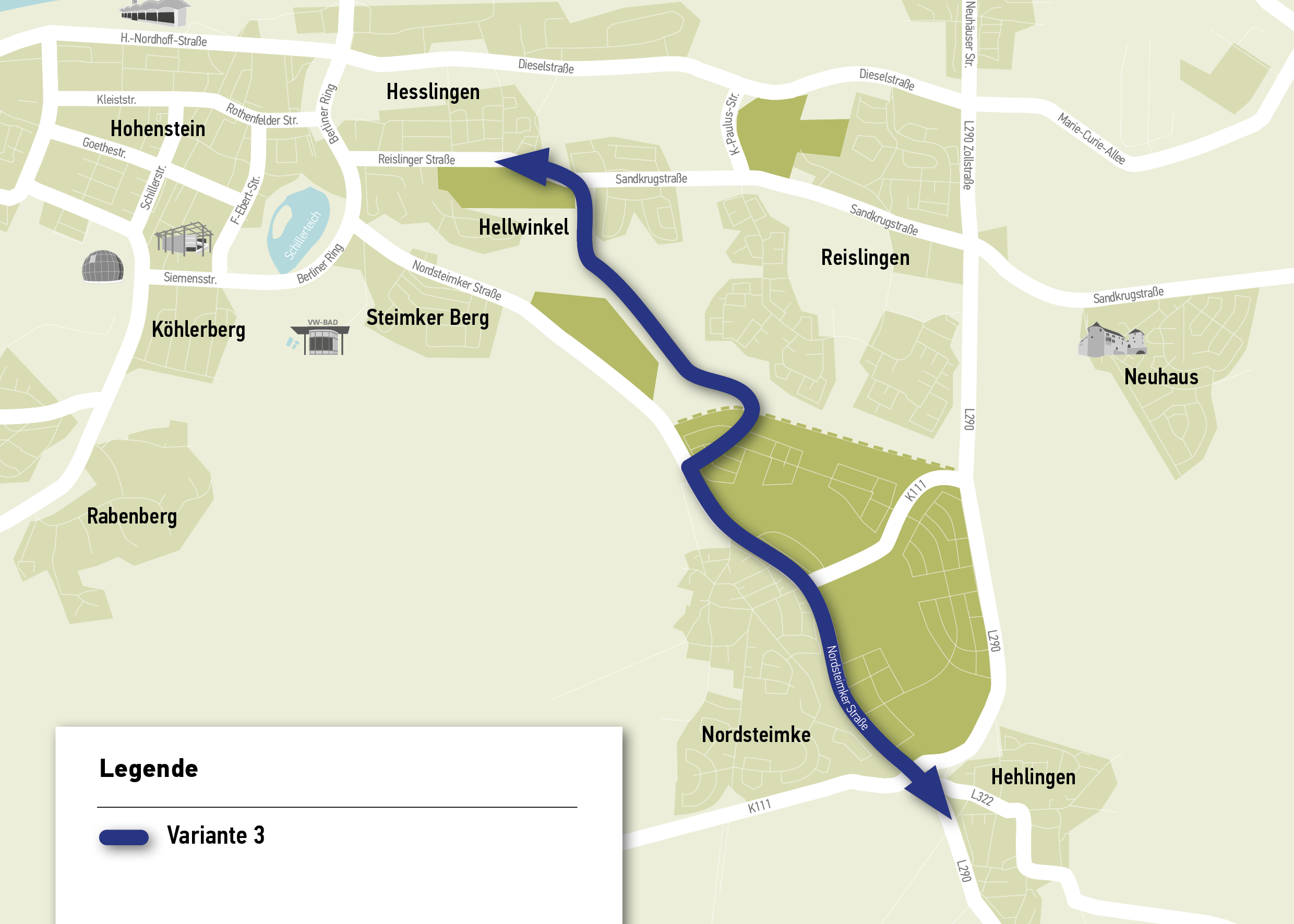
As a result of the two-stage study of variants, variants 2b, 2c and 3 were recommended for further in-depth planning or for implementation, which were considered to be almost equivalent in comparison. The naming of the variants is derived from the ten variants originally available at the beginning of the study. The following three variants were shortlisted for the AGR Außenbereich route:
Variant 2b
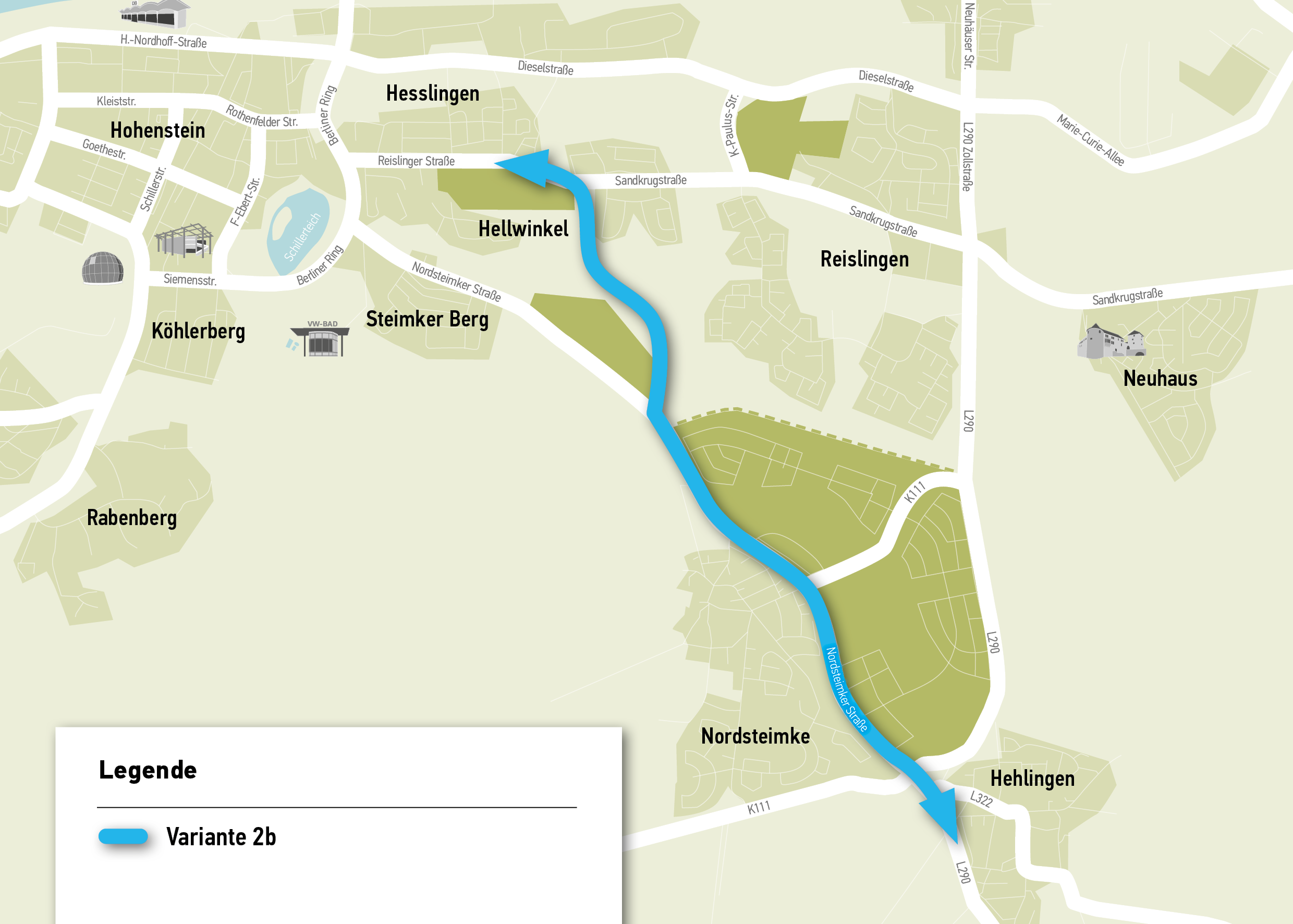
- no internal connection of the new construction areas
- development potential of 11,500 inhabitants
- travel time between start and end point is approx. 12 minutes
- direct line routing
Variant 2c
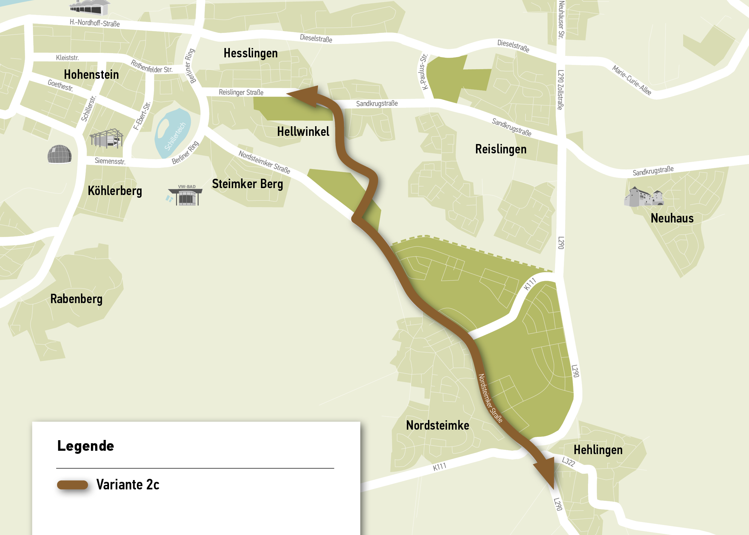
- Inner connection of the Steimker Gärten development area with shorter access routes
- development potential of 11,500 inhabitants
- travel time between start and end point is approx. 12 minutes
Variant 3
Variant 2c as preferred variant
- internal connection of the (northwestern) Sonnenkamp development area with shorter access routes
- development potential of 11,500 inhabitants
- the travel time between the starting point and the end point is approx. 12 minutes
From the investigation the emerged. The reason given for this was that the routing of variant 2c provides a very good connection to the Steimker Gärten residential development area thanks to a stop located in the development area. In the course of this, the AGR routing in the Steimker Gärten construction area was further optimized in the course of the construction area planning. Optimum framework conditions were worked out by mutual agreement with the developer, so that this route variant entailed the lowest implementation risks in terms of acceptance and legal protection. This is also due to the fact that the required area for AGR is already taken into account in the Steimker Gärten development plan.
-
Cross sections
For the area from the junction BG Steimker Gärten / K5 to the Hehlinger traffic circle along Nordsteimker Straße, various road cross-sections have already been worked out and evaluated. At the level of the Steimker Gärten construction area, building rights will be created by means of a development plan. However, the exact road cross-section has not yet been determined and is to be decided in the summer of 2019.
At the level of the Sonnenkamp development area, building rights are to be created in the future via the infrastructure development plan, which will then also specify the final design of the road space. So far, it is still unclear what the exact cross-section of the road will look like in the future.
-
Further steps
The following measures are planned as the next steps for the future:
- For individual sections, an object template is to be submitted to the policy for resolution
-
Initial situation
Against the background of the dynamic urban development and the development of the VW plant as a significant traffic generator in the urban area, an increase in traffic is forecast. This leads, among other things, to the necessity to think about new forms of supply and thus also about necessary traffic routes and infrastructure facilities. In order to handle the high commuter flows from the southern and eastern surroundings of Wolfsburg in a way that is compatible with the city, a P R facility was originally to be built in the area of the district of Hehlingen, which would also represent the end and starting point of the AGR. In anticipation of this, an investigation was carried out to determine which large-scale location on the L 290 would make sense. Here, a possible location in the Hehlingen area initially emerged. Against this background, a feasibility study was prepared for a possible location of such a facility.
-
Variant identification and evaluation
Variant determination
The first step in identifying variants was to analyze land availability and evaluate it in terms of the requirements for a P R plant. The feasibility study only includes the location of a possible P R facility. More in-depth studies on the structural design (e.g., ground-level parking lot or parking pallet) or a consideration of the currently ongoing studies on the mobility concept (bus or light rail system) have not yet been included in the study, as such decisions have not yet been made or corresponding planning has yet to take place.The main requirements/characteristics of the can be named as follows:
- highest possible utilization potential due to high location favorability, utilization attractiveness and safety perception
- suitable performance of the P R facility and the adjacent streets as well as the existence of reasonable expansion possibilities
- favorable transition possibilities to public transport in connection with attractive travel times against the background of the alternative onward journey to the destination by motorized individual transport
- economically and ecologically compatible development of the area, reduction of impacts, and
- ability to be combined with the interests of bicycle traffic.
An extensive and detailed evaluation process was conducted to assess whether the areas met the requirements. The objective evaluation criteria included:
- Accessibility for motor vehicle traffic
- Accessibility of the AGR terminus for pedestrian/bicycle traffic
- Integration into the public transport network
- Conflict of areas with other plans
- Possibility of expansion (relation to the size of the area)
- Technical development of the area with electricity, water, etc.
- Costs (investment costs, ongoing operating costs as well as maintenance and safety)
- Impact on people and environment
- Location of the P R facility in the classified road network
- attractiveness for pedestrians and cyclists as well as motor vehicle traffic (length of sidewalk, connection or development)
- social security
- Efficiency of the approaching roads
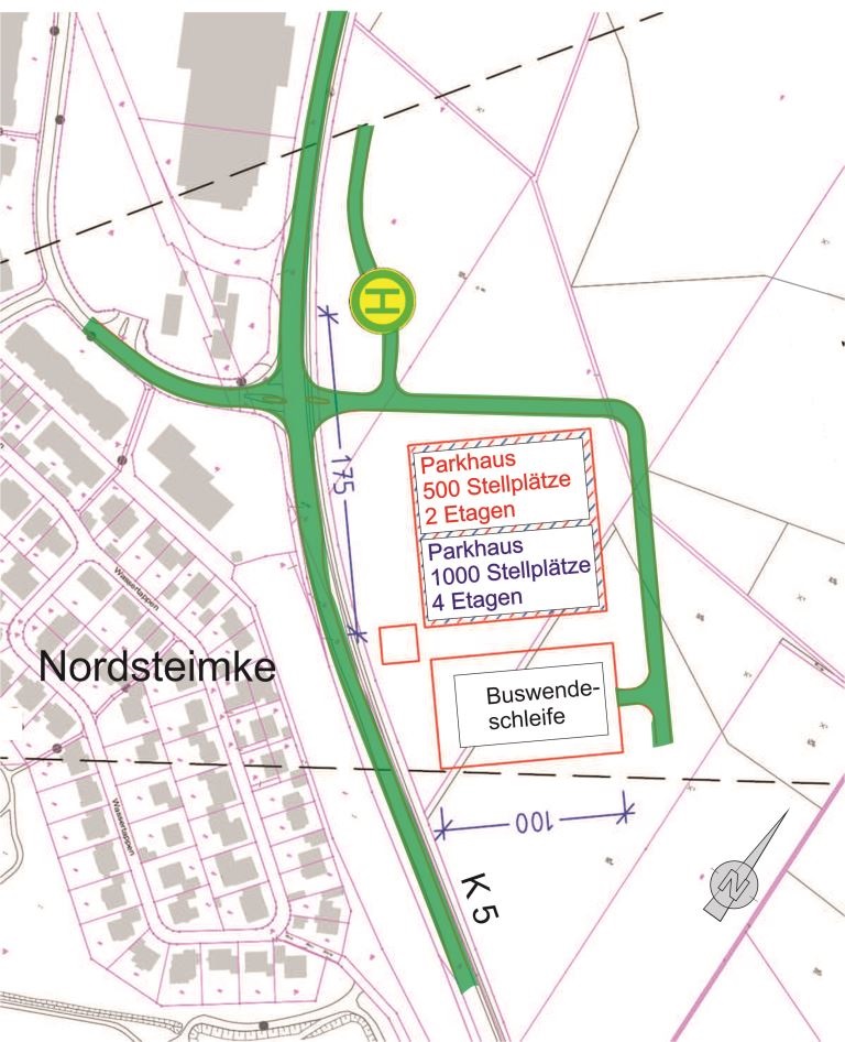
The following locations have been examined for a possible P R facility in the Hehlingen area.Variant 1: Hehlingen South
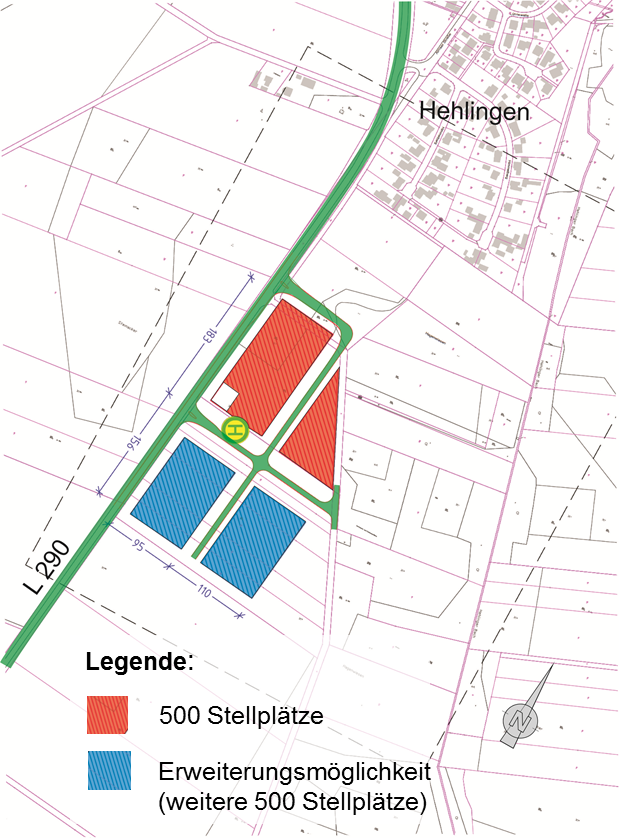
Variant 2: nursery
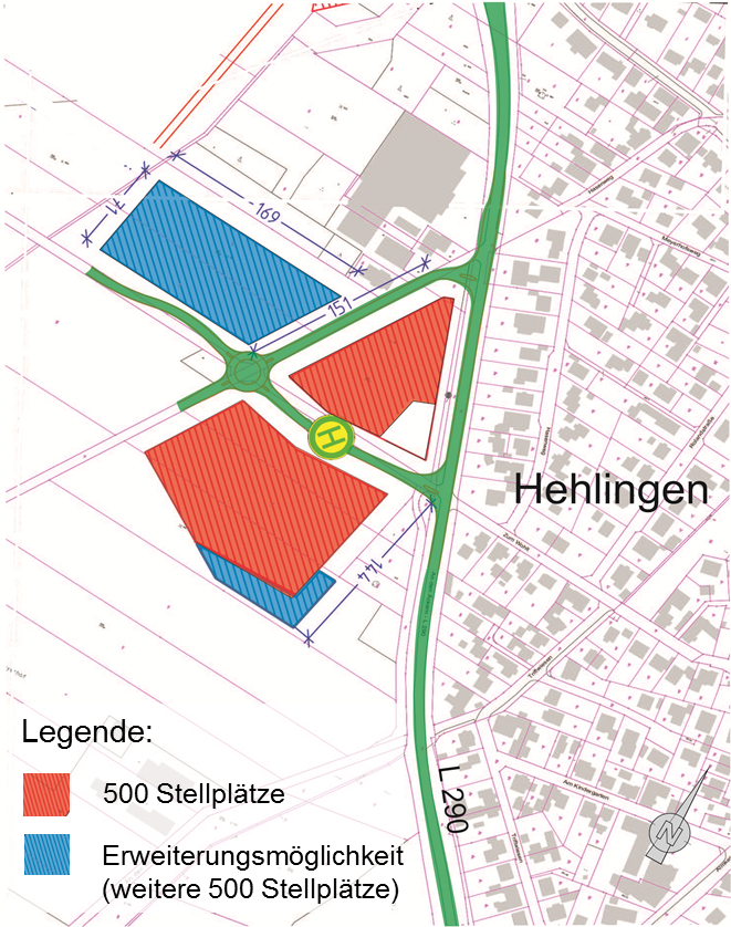
Variant 3: At the traffic circle
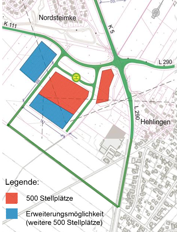
Variant 4: Sonnenkamp construction area
Preferred variant
Due to the good traffic flow, the high attractiveness and the possibility of urban integration, variant 3 emerged from the evaluation process as the best option.
-
Current status
Template V 2017/0272-1
In the course of planning for the end and beginning point of the AGR, several locations for a P R plant in the Hehlingen area were also investigated at the same time. The following results reflect the current status of the planning:- with the was decided by the council of the city of Wolfsburg in the meeting of 21.06.2017 the end point of the AGR at the height of the urban quarter in the future construction area Sonnenkamp.
- in a first building block, a temporary parking facility in the area of Quartier I or the planned campus with a contingent of 200 parking spaces is to serve as a P R offer
- Building rights for the P R facility have been secured via the infrastructure development plan, which is to become legally binding at the end of 2020.
-
Further steps
The following measures are planned for the further planning process:
- Specification of the exact location of the neighborhood garage in the urban quarter through an urban planning competition
- urban integration of the location in the overall context

"Alternative Green Route" (AGR)
In the future, local public transport should be so attractive, comfortable and fast that it represents a real alternative to the private car. Under the working title, a concept for local public transport was therefore developed with the aim of developing routes on which a high-quality local public transport service can be implemented. State-of-the-art vehicles with a tightly scheduled service, few stops and central interchanges are to make the trip fast and particularly comfortable for residents and commuters. On the AGR, buses will travel in a dedicated lane past the congestion to the city center or to the workplace, thus forming a much higher-quality public transport system than today. With the help of this high-quality public transport route, further potential for modal shift to public transport is to be mobilized. In this context, a provisional park-and-ride facility (P R) is to be built in the area of Quartier I in the Sonnenkamp construction area as a first building block, where commuters can park their cars and transfer to the AGR.